
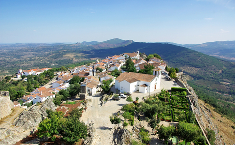
 The village of Marvão it is located at the top of the Serra do Sapoio, at an altitude of 860 meters, surrounded by the walls of Marvão Castle, presenting beautiful views over the Natural Park of Serra de São Mamede and the Apartadura Dam.
The municipality, with an area of 155 km2, is limited at the north and at east by Spain, at the south and west by the municipality of Portland and at northwest by Castelo de Vide.
On the municipality of Marvão, are known 24 dolmens and three menhirs, implanted essentially along of the Sever River and next to the granite outcrops lands, witnessing their monuments, the spaces lived by the Neolithic communities (12000 BC and 4000 BC), who settled within on the territory of the current municipality.
The oldest reference known about the Marvão tapirs Marvão remounts to the 17 th century more specifically to 1693, from a manuscript that was included in a packet of documents of donations to the Mercy of Marvão currently missing.
The historical heritage of Marvão is characterized by the fortifications (Castle) of Marvão, the Roman City of Amma, the Manueline Cruise (1525), the Pillory, the lime kilns of Excusa, the huts, the Cinquencentist Bridge, the churches of Marvão the Convent of Nossa Senhora da Estrela (1448), Antas and menhirs and the Tower of Portagem. Its natural heritage is characterized by its flora, fauna, of the Sever River and the Serra de São Mamede.
Marvão is a region in which at least, since the Roman Empire, its rocks are used as a refuge or as a strategic military point, due to its strategic position on the border line between the territories of Portugal and Spain.
The origins of Marvão remounts to the Roman Empire time when it was known as the Fortress of Ammaia. Marvão, would be consist in a protective fortification of the city of Amma, founded on the 1 st century, in a overlooking valley, whose remains can be actually visited.
With the Muslim invasions of Europe, verified between the 8th century and the 12th century, Marvão was occupied by the Muslims, being that on the 10th century, the Cordoban historian, Isa Ibn Ahmad Ar-Razi, identified Marvão as Amaia Fortress and as Amaia -the-Hill, between other names, a fact which raises the hypothesis that there would be a fortress at the top of the hill, that would have served the city of Ammaia, founded on 1 St century, being also the first known reference to the Marvão Fortress.
Besides the respective designations, the same historian designated Marvão as Amaia Mount and as Amaia of Ibn Maruán. Ibn Maruán was a muladi of emeritense noble lineage, who became famous in the last quarter of the 11 th century as a rebel and warlord of the war against the Emirate of Cordoba, on the context of civil wars realized between the different Muslim factions who occupied the Iberian Peninsula.
 The Ammaia Fortress on the municipality of Marvão, then served as a strategic refuge to the respective (re) founder of Badajoz, (where he created a sort of independent kingdom) when, in this capital, he felt threatened. This fact was verified on the year of 884 before the approaching of the troops of the Emir Muhammad, threatened to destroy the city and flee to Marvão.
Between 1160 and 1166, would occurred the Portuguese conquest of Marvão, on the period of the Christian Recon quest, by the King Afonso Henriques, the first king of Portugal, although it does not have definitively the knowledge if definitely, taking into account the counter-offensive of Almansor, realized between 1190/1191, to the line of the Tejo River, by the Muslim.
In 1226, Marvão received its first charter by the King D. Sancho II, having been one of the first royal charters granted in region the Alentejo region.
Marvão, was for centuries the scene of several attacks effectuated by the Spanish army and of fought battles on the context of the history of Portugal.
Concretely, this situation occurred in 1299, in the wars between the King D. Dinis and his brother D. Afonso, during the crisis of 1383-1385; on the restoration of independence period, between 1641 and 1668; during the War of the Spanish Succession between 1704 and 1712, in the War of the Oranges, (a short military episode occurred between Portugal and Spain in 1801), in the Liberal Wars, occurred between 1832-1834, opposing factions D. Pedro IV and D. Miguel and in the Civil War, in consequence of the rebellions of Maria da Fonte, in 1846 and of Patuleia, in 1847.
Equally, over the years, were effectuated several remodeling campaigns of the Marvão Castle, through different monarchs and later through different governments, after the implantation of the Republic, in Portugal in 1910, having given to the monument its current appearance.
The Marvão Castle it is inserted on the Natural Park of Serra de São Mamede, where it stands on the north side of the mountain, in a dominant position over the city of Marvão and strategic over the line of the border with Spain. In the past, the Castle allowed the control of the passage of the Sever River, a tributary of the Tejo River, fact that assured along the centuries, the attention of several monarchs, through several rehabilitation interventions.
The monument stands on a quartz ridge (relative to the mineral quartz), on the quota of 850 meters above the sea level, surrounding the village of Marvão. The walls are reinforced by towers and are distributed in concentric defensive lines.
The Marvão Castle it is classified as a National Monument by Decree-Law published in July 4, 1922, having the respective state intervention started in 1938, by initiative of the then Directorate-General for National Buildings and Monuments (DGEMN) . Since then, the respective heritage has been kept in a good conservation state.
The village and the rugged mountains, in which is located Marvão are included in the list of the candidates for the UNESCO World Heritage since 2000, having been presented a respective new candidature, since February 2011.


